


Winter came earlier than expected this November and I’d been hoping to climb Mt Washington and Mt Monroe early in the month before it snowed and got winter-like above treeline. Unfortunately, I sprained my ankle on November 3rd while hiking back from Mt Isolation and lost two weeks nursing it back to health. I really dodged a bullet with that injury: it could have been much worse. However, I have experience rehabbing a serious sprain and know how to assess one and to get it back into hiking shape.
There was some urgency to this because I’m hiking a peakbagging list called The Grid which requires climbing all of the White Mountain 4000 footers in each calendar month of the year. It’s one of the three most difficult lists in New Hampshire: The Grid, White Mountain Guide Redlining, and the NH 500 Highest.
The phrase “griding out” means that you’ve climbed a mountain in all 12 calendar months. Before this hike, I’d climbed Washington and Monroe in 11 separate months, sometime multiple times, with just November remaining.
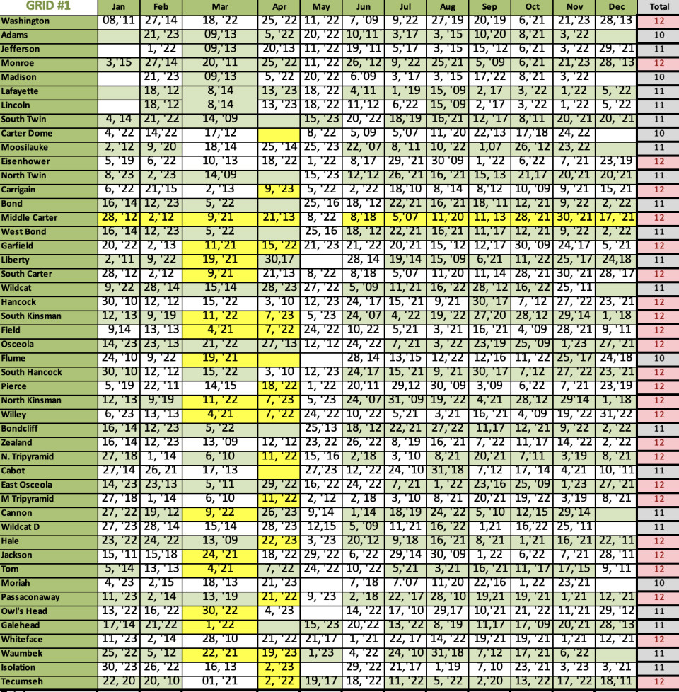
There are 48 peaks on The Grid list, so you need to climb 576 summits (48 x 12) to finish. I’m almost done (95%) but it’s down to the wire and I need to finish the outstanding mountains I have in each month or wait another year for that month to come around and try to finish them then. There’s a surprising number of people who’ve completed The Grid which is the most popular of the New Hampshire Triple Crown as the three lists are collectively known. A handful of people have completed all three.
The calendar requirement is what makes the Grid such a challenge since certain months like December, January, February, and April are particularly difficult to complete. The weather and trail conditions during those months in the White Mountains are really nasty.

At the start of November, I only had 5 peaks left to finish the month and they only required 3 hikes to complete:
- Mt Osceola and East Osceola
- Isolation
- Washington and Monroe
I banged out the Osceolas on Nov 1 and Isolation on Nov 3. The plan was to finish Washington and Monroe as soon as a weather window opened up to “Grid Out” the month of November as early as possible, just in case I needed to wait a long time before Washington and Monroe would be safe enough to climb. Potentially solo too, unless I could convince someone to join me. I’m lucky that I have a job where I can skip a day to go hiking when I please, as long as the work still gets done. Most people don’t, but I end up hiking solo a fair amount because of it.

As I recuperated, I watched the weather and worried that I’d lose the conditioning I’d acquired and would need to climb Monroe and Washington in winter conditions. Winter came early, and although it is still autumn for another month, winter conditions prevail on the higher summits.
After 10 days, I was ready for a test hike and climbed Carter Dome to assess my ankle and my fitness. That went much better than I could have hoped and knew I was ready for Monroe and Washington as soon as a weather window opened up. But the conditions on Monroe and Washington which are above treeline would be far more wintry than the tree-protected summit of Carter Dome.

I’m pretty cautious about climbing some of the higher peaks in the Whites and skip a lot of days that other people will hike despite very high winds and cold temperatures. If the winds are higher than 30 mph and the temperatures lower than 10F, I’ll usually find another more protected (by vegetation) peak to climb. Wearing a facemask and goggles for hours on end isn’t my idea of a good time.
But I didn’t have to wait long after my Carter Dome ascent for a good weather window to arrive. A low wind day under 20 mph was forecast, under sunny skies, albeit with a cold start of 6F. I decided this was too good to pass up and put on extra warm base layers for the initial ascent up Monroe, knowing that the sun would bring the temperatures up later in the day.

I arrived at Cog Hikers lot at 7:00 am, paid the $10/person parking fee, and headed up the Amoonsuc Link Trail to the Amonoosuc Ravine Trail for the 2100′ (3.1 miles) ascent to the Lakes of the Clouds hut at the base the Mt Montroe summit cone. I quickly switched to trail crampons and made good time on the steep climb. My trail crampons provided sufficient traction to the point just below the hut which is often covered by thick ice, but I was able to get past it with careful footwork.
Rather than stop at the hut (which is shuttered closed for the season), I climbed to the Monroe summit which is only about 250 feet above the hut. This involved slogging through some slippery powder but it was a short distance and I was the first person to summit that day. I didn’t linger but turned around immediately and headed back down, encountering several other hikers coming up including a friend named Alex who I’d met last December on a Zbonds Traverse.

When I arrived back at the hut, I ran into a woman who startled me coming around one of the building corners. I didn’t see her face, but I think I recognized her voice. She said, “We have to put a cowbell on you.” It took me a while to place that voice, but I think it was a hiker named Twinkle Toes (email me if it was you!). The last time I saw her was last November 2022 on Mt Madison. It’s a small world above treeline among people actively hiking the Grid, as Alex and Twinkle Toes are.
I stopped for a drink and eat some food at the hut before heading up toward Mt Washington, which is 1.5 miles and 1200′ of elevation gain further. The sun had warmed the air, so I stripped off my special KUIU long underwear, which can be removed without taking off your pants first.

I was tiring, but my goal was within reach so I shouldered on. The Crawford Path which climbs Washington from Monroe was covered in a light layer of powder but was pretty easygoing until I came to the Davis Trail junction and the powder got deeper and unsupportive. From there to the summit, I was climbing in about 8″ of powder with just my traction and no added flotation. I passed a few hikers coming down and a few passed me going up, but before I knew it I was at the summit sign.
The visibility and temperature at the summit of Mt Washington was optimal. I’d really landed a great day to climb both peaks. I’ve spent the past 10 years learning about winter weather patterns and forecasting in the White Mountains and it’s days like these where that experience really pays off.

Now to get off and back down safely. The fastest way off the west side of Washington is to follow the Cog Railroad access “road” which runs along the tourist railroad. It’s also convenient in a storm because it’s easier to follow without trying to spot the snow-covered cairns that mark other trails like the Jewell. This road is grotesque to follow most of the year because it’s covered with coal, creosote timbers, and other debris cast off by the railroad, but in winter that’s all thankfully covered in snow. It was still pretty bony going down the 3500′ descent with the light snow cover but made for a fast if boring exit back to my car.
I breathed a sigh of relief when I made it back to the car and cracked open the hot thermos of tea that I’d packed that morning. Two of the big peaks, Washington and Monroe, are gridded out with just a few more to go in the coming months: Adams and Madison, Jefferson, and Lincoln and Lafayette. I can feel this Grid journey is coming to a close, which saddens me, but I’m sure another multi-year hiking and backpacking quest will fill the void soon enough. Onward and by all means.
SectionHiker is reader-supported. We only make money if you purchase a product through our affiliate links. Help us continue to test and write unsponsored and independent gear reviews, beginner FAQs, and free hiking guides.